The viaduct is part of the A-67 motorway, is located between the municipalities of Bárcena de Pie de Concha and Molledo in the Autonomous Community of Cantabria.
[ external image ]
This structure is 721 metres long and rises up to 145 metres above the river Bisueña.
It not only holds the record for the highest bridge, but also for the widest in Spain.
[ external image ]
seen from the motorway on the north side of the viaduct (on the south side the Somaconcha tunnel)
site image Ferrovial (constructors of the work)
localistion: https://www.google.ca/maps/@43.1012995, ... !1e3?hl=en
http://www.mosingenieros.com/2010/02/vi ... abliz.html
Montabliz Viaduct (on the Ferrovial site)
Wikipedia on the Autovía Cantabria-Meseta (in Spanish language)
Spain pre-research tips
-
Louno Trucker
- Posts: 226
- Joined: 24 Mar 2020 11:42
- Location: Gironde, Nouvelle-Aquitaine, France
- Contact:
Viaducto de Montabliz
Last edited by Louno Trucker on 27 Oct 2020 23:39, edited 2 times in total.
TruckSim lover since 2017
I use DeepL Translator
I use DeepL Translator

Almería tips
Since you're including Almería, you can always give Almerians a reason to feel proud of their already lovely city by including any reference to ÍNDALO. It's okay to have a small índalo painted in your business or house gate to attract success and good luck, traditions 
https://en.wikipedia.org/wiki/Indalo
[ external image ]
Another thing typical from Almería is Beach Volley (Voley Playa in Spanish), there's always tournaments and sometimes they set a temporary stadium in Zapillo Beach (playa del Zapillo).
[ external image ]
Almerians are very proud of their filming locations and studios in Tarbernas desert as well as their beaches, Cabo de Gata-Níjar holds a wonderful coast.
[ external image ]
[ external image ]
Notice the pita tree already referenced in this thread at: viewtopic.php?f=249&t=267679&p=1386650& ... a#p1386650

Re: Spain pre-research tips
And not far from there, could be included this iconic ship:
[ external image ]
Reference
Location
Ship Location IRL
[ external image ]
Reference
Location
Ship Location IRL
-
plinio.lisboa.br
- Posts: 951
- Joined: 15 May 2019 16:27
- Location: Agua Boa, MT, Brazil
Re: black olives factory. Extremadura region, SPAIN.
Aceitunas Merino S.A.
City: Moraleja Region: Extremadura
Route: EX-108 Access to Portugal allows connecting the cities of: Castelo Branco (Pt) and Plasencia (Es).
Localization google maps: https://www.google.com/maps/@40.0514613 ... a=!3m1!1e3
Street view: https://www.google.com/maps/@40.051865, ... 384!8i8192
Good morning, today I would like to help with a research about a company that produces 80% black olives and 20% green olives.
Black olives are basically intended for salads and pizzas.
"Last year we received a million and a half kilos in the campaign and throughout the year we bought another half million," says the manager, who recalls that almost all of his purchases are made in the north of Cáceres, in the regions of Las Hurdes and Sierra de Gata, both for companies and for cooperatives.
quote available at: https://www.hoy.es/agro/201609/07/aceit ... o%2F201609 % 2F07% 2Faceituna-negra-cacerena-para-20160907001659-v.html
Other very important information to understand the olive industry is found in this Spanish language newspaper article.
Black olives are mainly intended for exports.
Export destinations, black olives: United States, Canada, Mexico. Europe: United Kingdom, France, Italy, Africa, Arab countries in North Africa and perhaps countries in the Middle East. Its main market is Italy and France.
Only 20% of olives are green and destined for the domestic market in Spain.
The company needs to buy the following inputs for its production:
chemical industry: sodium hydroxide (soda), ferrous gluconate.
Plastics Industry: packaging.
Metal industry: metal containers
wood industry: pallets
Plastic containers
https://www.google.com/maps/@40.0514838 ... 384!8i8192
Truck unloading some liquid product at the olive company
https://www.google.com/maps/@40.0514838 ... 384!8i8192
View from the rear of the factory
https://www.google.com/maps/@40.0511723 ... 384!8i8192
Front view of the olive factory
https://www.google.com/maps/@40.051865, ... 384!8i8192
https://www.google.com/maps/@40.0515572 ... 384!8i8192
Pictures of truck loaded with cargo at the company
https://www.google.com/maps/place/Aceit ... -6.6693825
Examples of containers for green olives
https://get.google.com/albumarchive/103 ... lnxJ?hl=es
Examples of containers for black olives
https://www.google.com/maps/place/Aceit ... -6.6693825#
DGT Vans Used by Local Police
I'm not sure if it's posted before (I searched the thread but found no posts related to it).
=======
DGT van
=======
As we all know already, DGT is the nation-wide organisation that manages roads, their traffic standards and safety. As far as I managed to read, they have a number of vans that are lent to different local police all over the country to watch over traffic, they're equipped with a radar and can run alcohol tests. These pictures are taken from newspapers from different parts of the territory, I've seen them from time to time stopped at certain dangerous places in my city as well.
Bottomline: there are thousands of different local police in Spain, they have different patrols and uniforms, but they can share these vehicules. You can even see these vehicules on Autovías as well (probably being driven by Guardia Civil agents). I think it's safe to add these to the game as another asset to police forces. They even have regular white vans with no letters or vynils, but with radars. They don't actually fine, there's always a patrol next to do the dirty job.
The most common vehicle is a FIAT SCUDO, but you can find FIAT Ulysse, Lancias and Peugeots as well (rare).
[ external image ]
[ external image ]
[ external image ]
[ external image ]
[ external image ]
[ external image ]
[ external image ]
[ external image ][ external image ]
[ external image ]
[ external image ]
[ external image ]
This car was lent to Madrid Local Police:
=======
DGT van
=======
As we all know already, DGT is the nation-wide organisation that manages roads, their traffic standards and safety. As far as I managed to read, they have a number of vans that are lent to different local police all over the country to watch over traffic, they're equipped with a radar and can run alcohol tests. These pictures are taken from newspapers from different parts of the territory, I've seen them from time to time stopped at certain dangerous places in my city as well.
Bottomline: there are thousands of different local police in Spain, they have different patrols and uniforms, but they can share these vehicules. You can even see these vehicules on Autovías as well (probably being driven by Guardia Civil agents). I think it's safe to add these to the game as another asset to police forces. They even have regular white vans with no letters or vynils, but with radars. They don't actually fine, there's always a patrol next to do the dirty job.
The most common vehicle is a FIAT SCUDO, but you can find FIAT Ulysse, Lancias and Peugeots as well (rare).
[ external image ]
[ external image ]
[ external image ]
[ external image ]
[ external image ]
[ external image ]
[ external image ]
[ external image ][ external image ]
[ external image ]
[ external image ]
[ external image ]
This car was lent to Madrid Local Police:
DGT vynils & car stickers
I forgot to add these
Hi-res DGT logo:
[ external image ]
Actual font used (notice that GENERAL is shortened by GRAL.) in cars:
[ external image ]
Private cars DGT environmental stickers (under revision), these are placed on the bottom right of the windshield:
[ external image ]
Private cars DGT ITV sticker (periodic inspection):
This one says GA because it's from GALICIA, every autonomous community stamps its logo on it... too small to even care about it, it would be cool to have the rectangle even if it's empty though (plain green, yellow or red).
[ external image ]
These stickers can have 3 colours (green, yellow and red alternatively) depending on the year of validity: 2019 is green, 2020 is yellow, 2021 is red.
[ external image ]
Location of the stickers: https://itvsanjavier.com/donde-se-debe- ... queta-itv/
[ external image ]
The top left sticker is for shared vehicles (VAO: vehículo de alta ocupación) to use preferent lanes in high traffic congestion cities.
Edit: stickers are something not every car has, ITV is for 4 year old private vehicles, trucks need to be just 2 years old.
Enviromental stickers are optional as of today.
High occupancy sticker is something rare outside big cities like Madrid or Barcelona.
-
plinio.lisboa.br
- Posts: 951
- Joined: 15 May 2019 16:27
- Location: Agua Boa, MT, Brazil
La Jonquera (Spain) to Le Perthus (France). Road: N II.
Perhaps, the video may be of interest on the road over Spain and its border area.
- La Jonquera (Spain) to Le Perthus (France). Road: N II. Route map: https://www.google.com/maps/dir/42.4028 ... 8b!1m0!3e0
---- Route itinerary -----
The video description is organized in the following way as main points:
00:06 Near Gran Jonquera Outlet & Shopping, Station Shell
https://www.google.com/maps/@42.4031055 ... 384!8i8192
01:32 Acess N II.
07:05 Exit Jonquera
07:16 - 07:34 viaduct A-7 (E-15).
07:56 - 08:05 Historic monument - Santa Martí del Forn del Vidre
Link: https://www.poblesdecatalunya.cat/element.php?e=8379
https://www.infojonquera.cat/noticia/34 ... -del-vidre
8:39 - 8:44 River El Llobregat
8:57 Signal: France 1 Km
9:21 Portic Road monitoring gantry (with cameras)
Unfortunately the video does not reach the border checkpoint. But you can see the building.
Monument Historic: Sant Lluís Rei de Bellaguarda
Drone view 1
https://www.youtube.com/watch?v=TByP-RoESXo
Drone view 2
https://www.youtube.com/watch?v=vcL1UpOW4BQ
walk through the fortress 1
https://www.youtube.com/watch?v=jIJ4H_sU9aM
walk through the fortress 2
https://www.youtube.com/watch?v=nmvL59NhaIs
walk through the fortress 3
https://www.youtube.com/watch?v=68GM9QUeRIs
walk through the fortress 4
https://www.youtube.com/watch?v=TBHKxW-aZx4
N II perspective vision to fortress
https://www.google.com/maps/@42.4577245 ... 384!8i8192
E-15 perspective vision to fortress
https://www.google.com/maps/@42.4581467 ... 384!8i8192
Road Maintenance Vehicles: CONSERVACIÓN
I know it's probably really late in terms of map development, but this detail is not really complicated, I haven't seen it in this thread so apologies if somebody already posted something about this.
Any vehicle working on road maintenance (removing roadkills, trimming the median vegetation, cleaning or repairing rails and signals) should have visible the word CONSERVACIÓN.
These vehicles are different for every region and their designs may vary, but there's a national design belonging to the Ministry of Transport
(GO TO PAGE 4 and beyond)
https://www.mitma.gob.es/recursos_mfom/ ... o22017.pdf
CONSERVACIÓN vehicles
[ external image ]
[ external image ]
http://elvigia.com/wp-content/uploads/2 ... vacion.jpg
[ external image ]
[ external image ]
[ external image ]
-
plinio.lisboa.br
- Posts: 951
- Joined: 15 May 2019 16:27
- Location: Agua Boa, MT, Brazil
LA LÍNEA DE LA CONCEPCIÓN.
LA LÍNEA DE LA CONCEPCIÓN.
This Spanish city is very important because it borders Gibraltar. If SCS Software resolves, at some point make Gibraltar playable. You will necessarily have to have this city and avenue (border and waterfront sea ) and highways presented in the video. Exactly the route that truckers take to enter and leave the territory of Gibraltar. Note that the moment of time is Twilight: the night is slowly falling, it is the transition phase from day to night, very beautiful scenes on the Spanish border to the south. Scientific information about the Twilight period in this Spanish city, can be obtained at the link: https://www.timeanddate.com/sun/@2515812
Video Route: Route:
https://www.google.com.br/maps/dir/36.1 ... a=!3m1!1e3
ITINERARY - ROUTE
0:41 Here it starts: the first marker identified in the video.
https://www.google.com.br/maps/@36.1562 ... 312!8i6656
? No time: Monument to Spanish Workers in Gibraltar
-----------------------------------------------------------------------------------------------
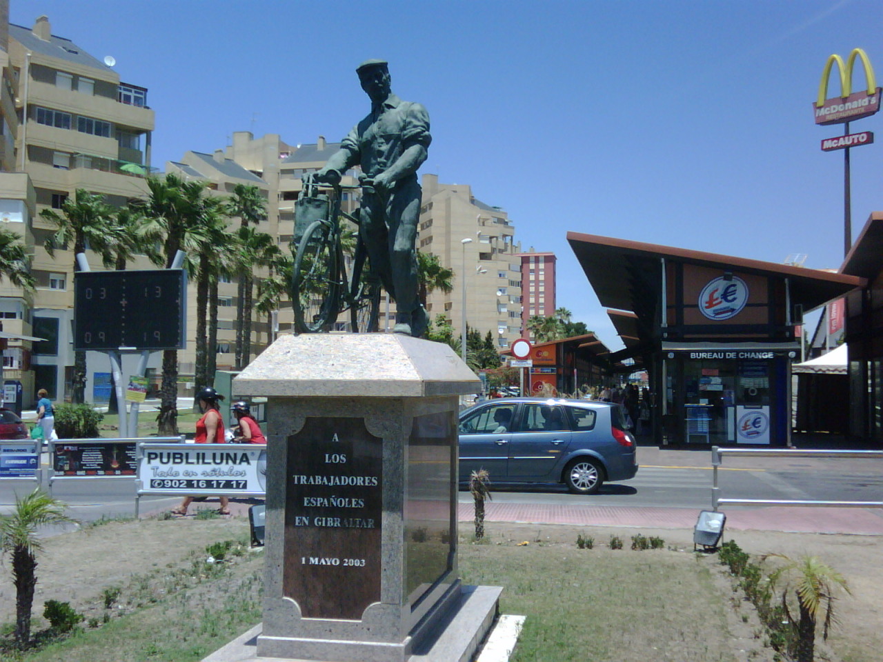
Monument to Spanish Workers in Gibraltar:
The video of the monument does not appear, but it is there.
Sometime in the time of the video that was cut in the edit.
----------------------------------------------------------------------------------------
-------------------------------------------------------------------------------
Monument to Spanish Workers in Gibraltar
1. Spanish Workers
https://1.bp.blogspot.com/-Y8GOTl74MUQ/ ... raltar.jpg
2. Spanish Workers
https://64.media.tumblr.com/840dc562c15 ... 2_1280.jpg
3. Spanish Workers
https://espanabizarra.tumblr.com/post/9 ... -linea/amp
4. Spanish Workers
https://static4-sevilla.abc.es/media/an ... 49@abc.jpg
1. Street view
https://www.google.com.br/maps/@36.1559 ... 312!8i6656
2. Street view
https://www.google.com.br/maps/@36.1563 ... 312!8i6656
Reference:
Below are two references that have photos in greater detail about monument "Spanish Workers ".
1 Reference:
https://espanabizarra.tumblr.com/post/9 ... -linea/amp
2 Reference:
https://www.tripadvisor.es/Attraction_R ... nce_o.html
----------------------------------------------------------------------------------------------------------------
1:45 Roundabout - 1.
Street view
https://www.google.com.br/maps/@36.1561 ... 312!8i6656
2:08 Roundabout - 2.
Street view
https://www.google.com.br/maps/@36.1563 ... 312!8i6656
2:52 Pedestrian signal: fluorescent flashing light.
It is important to note throughout the video: There are signs for pedestrian crossing, it is very interesting.
Street view
https://www.google.com.br/maps/@36.1582 ... 312!8i6656
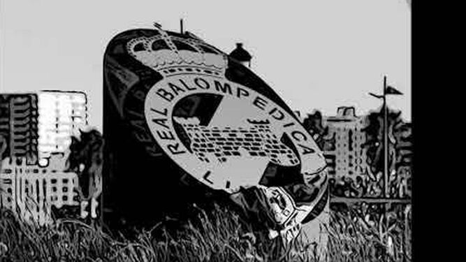
2:57 Roundabout - 3. Real Balompedica Linense.
At this moment in tribute to a sports team in the city.
Street view
https://www.google.com.br/maps/@36.1587 ... 312!8i6656
Reference:
https://www.europasur.es/2019/09/12/dep ... 67x375.jpg
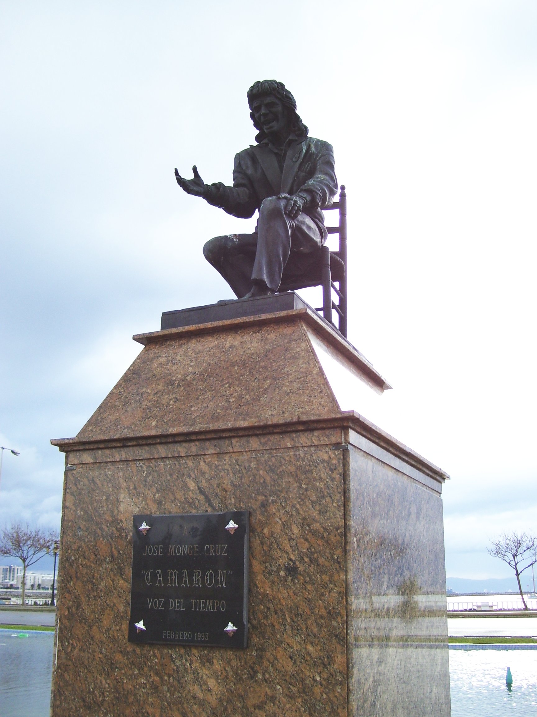
3:16 - 3:31 Plaza del Camarón
Is one of the most symbolic places in the city.
Plaza del Camarón - Monument - Honor to José Monge Cruz "Camarón de la Isla" (singer).
-----------------------------------------------------------
Photos statue: Monument - Honor to José Monge Cruz - Plaza del Camarón
1.Monument - Honor to José Monge Cruz
https://www.google.com.br/maps/@36.1600 ... 312!8i6656
2. Monument - Honor to José Monge Cruz
https://upload.wikimedia.org/wikipedia/ ... a_Isla.jpg
3. Monument - Honor to José Monge Cruz
https://twitter.com/dmflamenco/status/8 ... 80/photo/2
4. Monument - Honor to José Monge Cruz
https://mapio.net/images-p/90825709.jpg
5.Monument - Honor to José Monge Cruz
https://reformasyobras.wordpress.com/20 ... ousel-2824
Reference:
http://pajarrarcos.blogspot.com/2018/02 ... linea.html
I recommend for the construction of the statue in more detail the photos found in this reference above.
A little bit of music, on this posting Sunday. The video for curiosity the great singer of flamenco music from Andalusia, Spain.
Que Poderio Tendra - José Monge Cruz (Flamenco)
https://www.youtube.com/watch?v=bg3aKCz3DZs
I believe that now many people have understood why the Monument the singer appears sitting on the chair: it is one of the most iconic images of the singer's career.
This Spanish singer was one of those responsible for making Flamenco known worldwide, as one of the most important musical genres in Spanish music. He took the name of the region of Andalusia to the world and performed several shows in many countries in the world and also in several IBERIA cities.
----------------------------------------------------------------------------------
4:04 Roundabout of Trees
https://www.google.com.br/maps/@36.1621 ... 312!8i6656
4:56 Arcos roundabout.
It is one of the most beautiful roundabouts on this Avenue, (In my opinion).
https://www.google.com.br/maps/@36.1646 ... 312!8i6656
6:29 roundabout of lights
https://www.google.com.br/maps/@36.1667 ... 312!8i6656
7:12 Road sign for N 351 >> San Roque. Close to the city entrance roundabout. main roundabout.
https://www.google.com.br/maps/@36.1682 ... 312!8i6656
7:16 Reducing the speed to 0.25 it is possible to observe in the video time.
The signs that now compose this roundabout and that bear, the name of the city: "La Línea de la Concepción".
Contrary to what many may think, this is now the city's official entrance.
Why many people might think that the official entrance to the city would be via the A-383 highway. Although it is a beautiful and scenic highway, and also its connections with the city's coastal avenues. For historical reasons, the official entrance to the city is via the CA-34 highway.
--------------------------------------------------------------------------------------------
Main roundabout - official entrance to the city.
During 2019, an update was carried out at the roundabout. Where the name of the city now appears in metallic chrome letters.
1. Main roundabout
https://www.google.com.br/maps/@36.1682 ... 312!8i6656
2. Main roundabout
https://callereal.8directo.com/wp-conte ... ADnea.jpeg
3. Main roundabout
https://callereal.8directo.com/wp-conte ... nea-1.jpeg
-------------------------------------------------------------------------------------------------------------
7:35 Bridge - Arroyo del Cahón de Jimena.
The river stream under the bridge: It is the divider between the municipality of La Línea de la Concepción and the city of San Roque.
Google maps - Bridge - Arroyo del Cahón de Jimena.
https://www.google.com.br/maps/@36.1694 ... a=!3m1!1e3
Street view - Bridge - Arroyo del Cahón de Jimena.
https://www.google.com.br/maps/@36.1694 ... 312!8i6656
360° Bridge - Arroyo del Cahón de Jimena.
https://www.google.com.br/maps/@36.1693 ... 840!8i1919
The image shows the stream, bridge, beach, sea, building, and also the Rock of Gibraltar.
The suggestion for this location:
A camera moves system to capture the truck or movement of vehicles, passing through the location. The camera makes the movement in which it captures the Rock and the truck at the same time. The camera moves with the truck or vehicle until it crosses the bridge.
---------------------------------------------------------------------------------------------------------
7:43 road sign
Street view
https://www.google.com.br/maps/@36.1698 ... 312!8i6656
7:47 Acess Cernaval Group Shipyards
One of Spain's major naval companies. "Cernaval Group Shipyards" It is a Shipyard has large ships. Perhaps it is very interesting for the players to leave loads in this place like: Steel sheets, products for welds, things that could be researched about the Naval industry of shipyards specialized in large ships.
--------------------------------------------------------------------------------------------------------
1. Cernaval Shipyard - Málaga Port & Algeciras Port ( San Roque).
The video shows the company's two shipyards located in southern Spain, the shipyard in Malaga, and the shipyard in Algeciras (actually located in the small town of San Roque, which is nearby La Línea de la Concepción.
Video Cernaval: https://www.youtube.com/watch?v=qTaQKEOLx-I
00:00 - 01: 45 - Malaga, 01:53 - 04: 30 Algeciras ( San Roque).
Timing: The information contained. They allow a better knowledge of the geographic environment, and the company. Perhaps it will be last in creating the map in this region.
2. Cernaval Shipyard - Algeciras Port ( San Roque).
In this video; we can have new angles and perspectives on the space of the company's Shipyard.
Video Cernaval: https://www.youtube.com/watch?v=zroOIj6YFG0
-------------------------------------------------------------------------------------------------------------
8:46 - 9:08 Station oil & Elefante Azul (car-wash)
It is a good gas station location for the ETS2 game map, for this area of the Spain map.
The symbol of the elephant is also quite iconic. I believe it is an element that would allow recognition by many players in the region on the map of Spain.
-----------------------------------------------------------------------------------------------------
"Elefante Azul" (esp\ pt) (Traduction name: "Blue Elephant ")
Site company: https://elefanteazul.com/
you tube: https://www.youtube.com/channel/UCI5WDz ... a0U3krp4ng
In the link below it is possible to do the research to find and locate the network of car wash franchisees that perform the vehicle cleaning service in the Iberian peninsula Europe and Morocco:
Spain: https://elefanteazul.com/encuentra-tu-c ... ante-azul/
Portugal: https://www.google.com.br/maps/search/e ... 71101,6.3z
France: https://www.google.com.br/maps/search/E ... 5634827,6z
Swiss: https://www.google.com.br/maps/search/E ... 5188,7.74z
Morroco: https://www.google.com.br/maps/search/e ... 8232158,5z
So this would be approximately the distribution of the franchises of this company predominating in the Spanish territory, found in different parts of France being, more concentrated in the south of France. In some parts of Portugal. And also distributed in Morocco along a great route from North to South that takes us Agadir where the route begins to cross the Sahara desert and reach Mauritania, crossing Western Sahara by road.
Street view 1, "Elefante Azul" , San Roque
https://www.google.com.br/maps/@36.1730 ... 312!8i6656
Street view 2, "Elefante Azul" , San Roque
https://www.google.com.br/maps/@36.1732 ... 312!8i6656
Street view 3, "Elefante Azul" , San Roque
https://www.google.com.br/maps/@36.1732 ... 312!8i6656
--------------------------------------------------------------------------------------------------------------------------------
9:23 Restaurant - Brazilian spanish foods.
This is the marker (absolutely personal), but it helped enough to signal the analysis of the Route.
Street view
https://www.google.com.br/maps/@36.1742 ... 312!8i6656
10:54 "Parroquia de la Inmaculada"
Is the only church on the route. It has a very interesting and also very iconic design.
Street view
https://www.google.com.br/maps/@36.1768 ... 312!8i6656
Reference:
https://upload.wikimedia.org/wikipedia/ ... 012168.jpg
11:38 - 11:42 Iconic bakery
I find this marker quite interesting and unique on the way.
this set of simple home business outlets is quite beautiful, and also very different, especially the bakery! Your chimney absolutely incredible, in being different! The blue building next door is also a small shop like so many others that exist in this region of the highway, it is a beautiful attraction.
https://www.google.com.br/maps/@36.1779 ... 312!8i6656
12:18 road sign.
https://www.google.com.br/maps/@36.1810 ... 312!8i6656
13:04 road sign.
https://www.google.com.br/maps/@36.1846 ... 312!8i6656
13:37 viaduct
https://www.google.com.br/maps/@36.1891 ... 312!8i6656
13:51 last roundabout shown in the video. Finalization.
https://www.google.com.br/maps/@36.1910 ... 312!8i6656
---------------------------------------
Monument: Spanish Workers
With little more research we discovered that there is a second monument in honor of the "Spanish worker".
An exact replica of the monument in La Línea de la Concepción. The monument is located in the city of São Roque with a beautiful view of the sea and the Rock of Gibraltar in the background. It looks like photoshop, but it's real. Very beautiful. Unfortunately the place is not accessible for cars and trucks and is situated in a square close to the sea.
Monument to Spanish Workers in Gibraltar 2.
Localization: https://www.google.com.br/maps/@36.1813 ... a=!3m1!1e3
Iconic landscape: Monument to Spanish Workers in Gibraltar 2.
Reference: https://1.bp.blogspot.com/-N6sCEJLiugU/ ... ultura.jpg
But it is possible to do an event where the Truck Driver when parking the truck (even if temporary) in the parking in this image of Google Maps. As a trucker shown in the google maps image shows. Probably, exactly visiting the monument most likely to take pictures of the place.
Link: https://www.google.com.br/maps/@36.1821 ... a=!3m1!1e3
The street view shows the entrance to the park where the trucker in the Google Maps satellite images ends up entering his truck. Temporary parking with the probable purpose of visiting the monument site.
Link:
https://www.google.com.br/maps/@36.1819 ... 312!8i6656
Then SCS Software could make this location one of those to be discovered. The result is a short video showing this monument "Spanish Worker" with the Rock of Gibraltar in the background. Nearby cargo area? They are diverse. View the nearby oil complex.
Link: https://www.google.com.br/maps/@36.1842 ... a=!3m1!1e3
-------------------------------------------
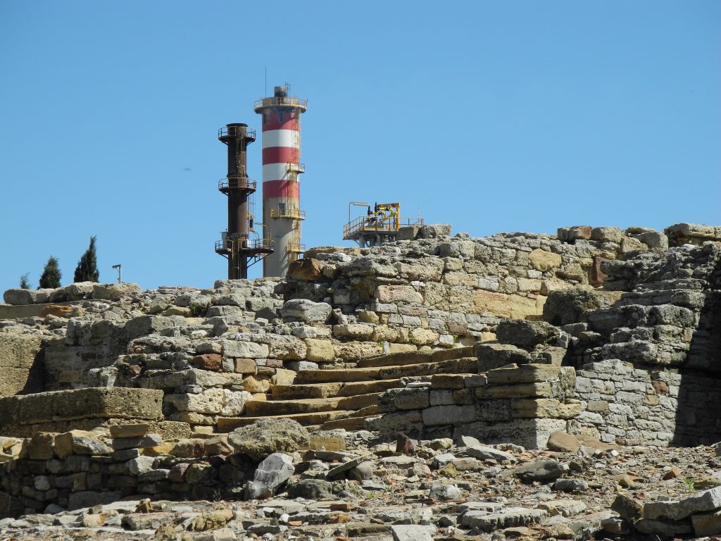
"Yacimiento Arqueológico Romano Carteia":
This could be another place to be discovered in the Euro Truck 2 game world, map of Spain. For that it would be necessary to do a photographic research on the ruins, and seek to have a layout of this ancient city. Then cross-check this information to perform 3D reconstitution of this environment, as it is today.
1. Ruins Carteia Video: Video: https://www.youtube.com/watch?v=JThvXMf40Sw
2. Ruins Carteia. Video: https://www.youtube.com/watch?v=naETm0jebeA
3. Carteia - Roman theater. Video: https://www.youtube.com/watch?v=ZSt_KGD6i0Y
Photo iconic : https://viatorimperi.es/wp-content/uplo ... 24x768.jpg
The references below tell a little of the history (+ Photos) of this ancient Roman city called "Carteia" and that previously in the 7th century BC was founded as a Phoenician city.
Reference: https://www.sanroque.es/turismo/carteia ... que-romana
Reference: https://historia.nationalgeographic.com ... altar_7849
The discovery of this location can be another option of finding a place in ETS 2. The player parking the truck in the car park (for a temporary time) at the location at the link: https://www.google.com.br/maps/@36.1822 ... a=!3m1!1e3
Coincidentally, it is the same parking area for the discovery of "Monument No. 2 in honor of Spanish workers", mentioned above.
Then the trucker player, in this place would have 2 options of interesting places to discover, while making his cargo trips through southern Spain and Gibraltar.
This Spanish city is very important because it borders Gibraltar. If SCS Software resolves, at some point make Gibraltar playable. You will necessarily have to have this city and avenue (border and waterfront sea ) and highways presented in the video. Exactly the route that truckers take to enter and leave the territory of Gibraltar. Note that the moment of time is Twilight: the night is slowly falling, it is the transition phase from day to night, very beautiful scenes on the Spanish border to the south. Scientific information about the Twilight period in this Spanish city, can be obtained at the link: https://www.timeanddate.com/sun/@2515812
Video Route: Route:
https://www.google.com.br/maps/dir/36.1 ... a=!3m1!1e3
ITINERARY - ROUTE
0:41 Here it starts: the first marker identified in the video.
https://www.google.com.br/maps/@36.1562 ... 312!8i6656
? No time: Monument to Spanish Workers in Gibraltar
-----------------------------------------------------------------------------------------------
Monument to Spanish Workers in Gibraltar:
The video of the monument does not appear, but it is there.
Sometime in the time of the video that was cut in the edit.
----------------------------------------------------------------------------------------
-------------------------------------------------------------------------------
Monument to Spanish Workers in Gibraltar
1. Spanish Workers
https://1.bp.blogspot.com/-Y8GOTl74MUQ/ ... raltar.jpg
2. Spanish Workers
https://64.media.tumblr.com/840dc562c15 ... 2_1280.jpg
3. Spanish Workers
https://espanabizarra.tumblr.com/post/9 ... -linea/amp
4. Spanish Workers
https://static4-sevilla.abc.es/media/an ... 49@abc.jpg
1. Street view
https://www.google.com.br/maps/@36.1559 ... 312!8i6656
2. Street view
https://www.google.com.br/maps/@36.1563 ... 312!8i6656
Reference:
Below are two references that have photos in greater detail about monument "Spanish Workers ".
1 Reference:
https://espanabizarra.tumblr.com/post/9 ... -linea/amp
2 Reference:
https://www.tripadvisor.es/Attraction_R ... nce_o.html
----------------------------------------------------------------------------------------------------------------
1:45 Roundabout - 1.
Street view
https://www.google.com.br/maps/@36.1561 ... 312!8i6656
2:08 Roundabout - 2.
Street view
https://www.google.com.br/maps/@36.1563 ... 312!8i6656
2:52 Pedestrian signal: fluorescent flashing light.
It is important to note throughout the video: There are signs for pedestrian crossing, it is very interesting.
Street view
https://www.google.com.br/maps/@36.1582 ... 312!8i6656
2:57 Roundabout - 3. Real Balompedica Linense.
At this moment in tribute to a sports team in the city.
Street view
https://www.google.com.br/maps/@36.1587 ... 312!8i6656
Reference:
https://www.europasur.es/2019/09/12/dep ... 67x375.jpg
3:16 - 3:31 Plaza del Camarón
Is one of the most symbolic places in the city.
Plaza del Camarón - Monument - Honor to José Monge Cruz "Camarón de la Isla" (singer).
-----------------------------------------------------------
Photos statue: Monument - Honor to José Monge Cruz - Plaza del Camarón
1.Monument - Honor to José Monge Cruz
https://www.google.com.br/maps/@36.1600 ... 312!8i6656
2. Monument - Honor to José Monge Cruz
https://upload.wikimedia.org/wikipedia/ ... a_Isla.jpg
3. Monument - Honor to José Monge Cruz
https://twitter.com/dmflamenco/status/8 ... 80/photo/2
4. Monument - Honor to José Monge Cruz
https://mapio.net/images-p/90825709.jpg
5.Monument - Honor to José Monge Cruz
https://reformasyobras.wordpress.com/20 ... ousel-2824
Reference:
http://pajarrarcos.blogspot.com/2018/02 ... linea.html
I recommend for the construction of the statue in more detail the photos found in this reference above.
A little bit of music, on this posting Sunday. The video for curiosity the great singer of flamenco music from Andalusia, Spain.
Que Poderio Tendra - José Monge Cruz (Flamenco)
https://www.youtube.com/watch?v=bg3aKCz3DZs
I believe that now many people have understood why the Monument the singer appears sitting on the chair: it is one of the most iconic images of the singer's career.
This Spanish singer was one of those responsible for making Flamenco known worldwide, as one of the most important musical genres in Spanish music. He took the name of the region of Andalusia to the world and performed several shows in many countries in the world and also in several IBERIA cities.
----------------------------------------------------------------------------------
4:04 Roundabout of Trees
https://www.google.com.br/maps/@36.1621 ... 312!8i6656
4:56 Arcos roundabout.
It is one of the most beautiful roundabouts on this Avenue, (In my opinion).
https://www.google.com.br/maps/@36.1646 ... 312!8i6656
6:29 roundabout of lights
https://www.google.com.br/maps/@36.1667 ... 312!8i6656
7:12 Road sign for N 351 >> San Roque. Close to the city entrance roundabout. main roundabout.
https://www.google.com.br/maps/@36.1682 ... 312!8i6656
7:16 Reducing the speed to 0.25 it is possible to observe in the video time.
The signs that now compose this roundabout and that bear, the name of the city: "La Línea de la Concepción".
Contrary to what many may think, this is now the city's official entrance.
Why many people might think that the official entrance to the city would be via the A-383 highway. Although it is a beautiful and scenic highway, and also its connections with the city's coastal avenues. For historical reasons, the official entrance to the city is via the CA-34 highway.
--------------------------------------------------------------------------------------------
Main roundabout - official entrance to the city.
During 2019, an update was carried out at the roundabout. Where the name of the city now appears in metallic chrome letters.
1. Main roundabout
https://www.google.com.br/maps/@36.1682 ... 312!8i6656
2. Main roundabout
https://callereal.8directo.com/wp-conte ... ADnea.jpeg
3. Main roundabout
https://callereal.8directo.com/wp-conte ... nea-1.jpeg
-------------------------------------------------------------------------------------------------------------
7:35 Bridge - Arroyo del Cahón de Jimena.
The river stream under the bridge: It is the divider between the municipality of La Línea de la Concepción and the city of San Roque.
Google maps - Bridge - Arroyo del Cahón de Jimena.
https://www.google.com.br/maps/@36.1694 ... a=!3m1!1e3
Street view - Bridge - Arroyo del Cahón de Jimena.
https://www.google.com.br/maps/@36.1694 ... 312!8i6656
360° Bridge - Arroyo del Cahón de Jimena.
https://www.google.com.br/maps/@36.1693 ... 840!8i1919
The image shows the stream, bridge, beach, sea, building, and also the Rock of Gibraltar.
The suggestion for this location:
A camera moves system to capture the truck or movement of vehicles, passing through the location. The camera makes the movement in which it captures the Rock and the truck at the same time. The camera moves with the truck or vehicle until it crosses the bridge.
---------------------------------------------------------------------------------------------------------
7:43 road sign
Street view
https://www.google.com.br/maps/@36.1698 ... 312!8i6656
7:47 Acess Cernaval Group Shipyards
One of Spain's major naval companies. "Cernaval Group Shipyards" It is a Shipyard has large ships. Perhaps it is very interesting for the players to leave loads in this place like: Steel sheets, products for welds, things that could be researched about the Naval industry of shipyards specialized in large ships.
--------------------------------------------------------------------------------------------------------
1. Cernaval Shipyard - Málaga Port & Algeciras Port ( San Roque).
The video shows the company's two shipyards located in southern Spain, the shipyard in Malaga, and the shipyard in Algeciras (actually located in the small town of San Roque, which is nearby La Línea de la Concepción.
Video Cernaval: https://www.youtube.com/watch?v=qTaQKEOLx-I
00:00 - 01: 45 - Malaga, 01:53 - 04: 30 Algeciras ( San Roque).
Timing: The information contained. They allow a better knowledge of the geographic environment, and the company. Perhaps it will be last in creating the map in this region.
2. Cernaval Shipyard - Algeciras Port ( San Roque).
In this video; we can have new angles and perspectives on the space of the company's Shipyard.
Video Cernaval: https://www.youtube.com/watch?v=zroOIj6YFG0
-------------------------------------------------------------------------------------------------------------
8:46 - 9:08 Station oil & Elefante Azul (car-wash)
It is a good gas station location for the ETS2 game map, for this area of the Spain map.
The symbol of the elephant is also quite iconic. I believe it is an element that would allow recognition by many players in the region on the map of Spain.
-----------------------------------------------------------------------------------------------------
"Elefante Azul" (esp\ pt) (Traduction name: "Blue Elephant ")
Site company: https://elefanteazul.com/
you tube: https://www.youtube.com/channel/UCI5WDz ... a0U3krp4ng
In the link below it is possible to do the research to find and locate the network of car wash franchisees that perform the vehicle cleaning service in the Iberian peninsula Europe and Morocco:
Spain: https://elefanteazul.com/encuentra-tu-c ... ante-azul/
Portugal: https://www.google.com.br/maps/search/e ... 71101,6.3z
France: https://www.google.com.br/maps/search/E ... 5634827,6z
Swiss: https://www.google.com.br/maps/search/E ... 5188,7.74z
Morroco: https://www.google.com.br/maps/search/e ... 8232158,5z
So this would be approximately the distribution of the franchises of this company predominating in the Spanish territory, found in different parts of France being, more concentrated in the south of France. In some parts of Portugal. And also distributed in Morocco along a great route from North to South that takes us Agadir where the route begins to cross the Sahara desert and reach Mauritania, crossing Western Sahara by road.
Street view 1, "Elefante Azul" , San Roque
https://www.google.com.br/maps/@36.1730 ... 312!8i6656
Street view 2, "Elefante Azul" , San Roque
https://www.google.com.br/maps/@36.1732 ... 312!8i6656
Street view 3, "Elefante Azul" , San Roque
https://www.google.com.br/maps/@36.1732 ... 312!8i6656
--------------------------------------------------------------------------------------------------------------------------------
9:23 Restaurant - Brazilian spanish foods.
This is the marker (absolutely personal), but it helped enough to signal the analysis of the Route.
Street view
https://www.google.com.br/maps/@36.1742 ... 312!8i6656
10:54 "Parroquia de la Inmaculada"
Is the only church on the route. It has a very interesting and also very iconic design.
Street view
https://www.google.com.br/maps/@36.1768 ... 312!8i6656
Reference:
https://upload.wikimedia.org/wikipedia/ ... 012168.jpg
11:38 - 11:42 Iconic bakery
I find this marker quite interesting and unique on the way.
this set of simple home business outlets is quite beautiful, and also very different, especially the bakery! Your chimney absolutely incredible, in being different! The blue building next door is also a small shop like so many others that exist in this region of the highway, it is a beautiful attraction.
https://www.google.com.br/maps/@36.1779 ... 312!8i6656
12:18 road sign.
https://www.google.com.br/maps/@36.1810 ... 312!8i6656
13:04 road sign.
https://www.google.com.br/maps/@36.1846 ... 312!8i6656
13:37 viaduct
https://www.google.com.br/maps/@36.1891 ... 312!8i6656
13:51 last roundabout shown in the video. Finalization.
https://www.google.com.br/maps/@36.1910 ... 312!8i6656
---------------------------------------
Monument: Spanish Workers
With little more research we discovered that there is a second monument in honor of the "Spanish worker".
An exact replica of the monument in La Línea de la Concepción. The monument is located in the city of São Roque with a beautiful view of the sea and the Rock of Gibraltar in the background. It looks like photoshop, but it's real. Very beautiful. Unfortunately the place is not accessible for cars and trucks and is situated in a square close to the sea.
Monument to Spanish Workers in Gibraltar 2.
Localization: https://www.google.com.br/maps/@36.1813 ... a=!3m1!1e3
Iconic landscape: Monument to Spanish Workers in Gibraltar 2.
Reference: https://1.bp.blogspot.com/-N6sCEJLiugU/ ... ultura.jpg
But it is possible to do an event where the Truck Driver when parking the truck (even if temporary) in the parking in this image of Google Maps. As a trucker shown in the google maps image shows. Probably, exactly visiting the monument most likely to take pictures of the place.
Link: https://www.google.com.br/maps/@36.1821 ... a=!3m1!1e3
The street view shows the entrance to the park where the trucker in the Google Maps satellite images ends up entering his truck. Temporary parking with the probable purpose of visiting the monument site.
Link:
https://www.google.com.br/maps/@36.1819 ... 312!8i6656
Then SCS Software could make this location one of those to be discovered. The result is a short video showing this monument "Spanish Worker" with the Rock of Gibraltar in the background. Nearby cargo area? They are diverse. View the nearby oil complex.
Link: https://www.google.com.br/maps/@36.1842 ... a=!3m1!1e3
-------------------------------------------
"Yacimiento Arqueológico Romano Carteia":
This could be another place to be discovered in the Euro Truck 2 game world, map of Spain. For that it would be necessary to do a photographic research on the ruins, and seek to have a layout of this ancient city. Then cross-check this information to perform 3D reconstitution of this environment, as it is today.
1. Ruins Carteia Video: Video: https://www.youtube.com/watch?v=JThvXMf40Sw
2. Ruins Carteia. Video: https://www.youtube.com/watch?v=naETm0jebeA
3. Carteia - Roman theater. Video: https://www.youtube.com/watch?v=ZSt_KGD6i0Y
Photo iconic : https://viatorimperi.es/wp-content/uplo ... 24x768.jpg
The references below tell a little of the history (+ Photos) of this ancient Roman city called "Carteia" and that previously in the 7th century BC was founded as a Phoenician city.
Reference: https://www.sanroque.es/turismo/carteia ... que-romana
Reference: https://historia.nationalgeographic.com ... altar_7849
The discovery of this location can be another option of finding a place in ETS 2. The player parking the truck in the car park (for a temporary time) at the location at the link: https://www.google.com.br/maps/@36.1822 ... a=!3m1!1e3
Coincidentally, it is the same parking area for the discovery of "Monument No. 2 in honor of Spanish workers", mentioned above.
Then the trucker player, in this place would have 2 options of interesting places to discover, while making his cargo trips through southern Spain and Gibraltar.
Basque Country Welcoming Boards - National Roads Network
I think these ones haven't been published here, welcoming signposts to Euskal Herria (Basque Country). According to Google there are quite a few of them, but the pictograms can be a bit dodgy, there's a bit of a quarrel between Basque Country actual government and the neighbouring region of Navarra, the former thinks the latter belong to them and have included reference to Navarra in their welcoming signposts, the others sued and they won the trial, remove all reference to them on the boards (but I'm not sure if it's totally happening).
[ external image ]
[ external image ]
In secondary roads, ONGI ETORRI (welcome)
[ external image ]
===========================
===========================
Sometimes, when you leave urban territory or when you enter the beginning of a road controlled by the state, you may find this signpost indicating that you're ENTERING THE NATIONAL ROAD NETWORK.
[ external image ]
[ external image ]
[ external image ]
In secondary roads, ONGI ETORRI (welcome)
[ external image ]
===========================
===========================
Sometimes, when you leave urban territory or when you enter the beginning of a road controlled by the state, you may find this signpost indicating that you're ENTERING THE NATIONAL ROAD NETWORK.
[ external image ]
Who is online
Users browsing this forum: No registered users and 4 guests