MINERAL PRODUCTION IN THE ISLANDS, GREECE: CONNECTION OF THE CEMENT INDUSTRY. GYALIS ISLAND. Pumice Mine.
In today's search:
Let's talk about a very great relationship that exists between the islands of Greece in mineral production, with the activities of the cement industry in mainland Greece, and the country's archipelagos. Mining on the Greek Aegean islands, Greek, is also important for the cement industry in other parts of the world. And we found a company that does this in Greece, and it belongs to the "Lafargue" group. We also added a little curiosity about the other possible applications of these minerals. Let's start with a very beautiful island in Greece, and also of continental and worldwide importance: Gyali Island.
Although direct road transport between mainland Greece and the small mineral island is not possible.
It is possible to transport machinery for mining to the mineral island.
Cargo trucks with heavy mining machinery can transport, through the Maritime Road System of Greece's Ferries, to some nearby Islands.
Route Trucks:
The route studied would be as follows: 1. Porto Piraeus (Πειραιάς) in Continental Greece bound for the port in Hermópolis (Ερμούπολη) on the island of Siros. 2. Port of Hermópolis (Ερμούπολη) on the island of Siros, bound for the port in Kos (Κως), on the island Kos. 3. Port of Kos (Κως) on the island of Kos, bound for Mandraki port (Μανδρακ) on Nisiros Island.
Ferry routes: https://www.bluestarferries.com/en/trav ... t-map.html
1. Port Piraeus (Πειραιάς)
2. Port Hermópolis (Ερμούπολη) - Syros island: https://www.youtube.com/watch?v=3iy30_8a9FU
3. Port (Κως) - Kos island: https://www.youtube.com/watch?v=7r7StfHkacg
4. Port Mandraki (Μανδρακ): https://www.youtube.com/watch?v=-n1ET19Kq3U
"Gyalis (Γυαλί) the pearl of the Dodecanese (Δωδεκάνησα) in the Aegean Sea": ETS 2 game suggestion:
The importance of research on this mineral island Gyalis is for the game Euro Truck 2, in the suggestion of the possibility of building a small 3D cinematographic film of the island, its mineral activity including machines working, miners working, and minerals passing through conveyor belts, and ship being loaded during the day.
With some variations of cargo ships sailing, other cargo ships waiting nearby, some contrasts with sunrise and sunset. In the end; creativity the SCS team has.
And this short video the player could have the option of viewing, as soon as he delivers the machinery at the headquarters of the company, which is on the island of Nisiros in the city of Mandrake.
Physical aspect of Gyali island:
Glass, Gyali, Yali are some of the best known names for the island, their origin is volcanic, the Giali volcano is inactive.The island Gyali is rich in "pumice" and "perlite" are extracted by a mining company. minerals are destined for the international industrial market for export and the Greek national industrial market.
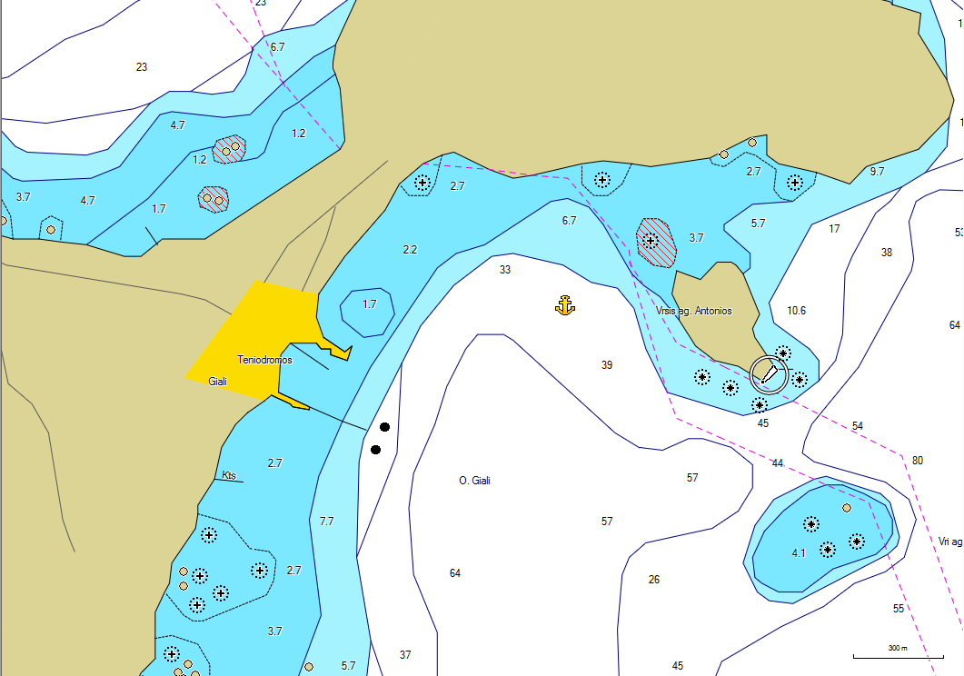
It is located between Kos and Nisyros (at a distance of about 7 km). It has an area of 4.6 square kilometers. The longest distance to the island is 5 km on the North / Northeast-South / Southwest axis. The largest width of the island is about 2.1 km, while the smallest is less than 500 m.
Nautical chart: https://www.nks.gr/images/maps/yali.png
Reference: https://www.nks.gr/ports/yali-island-port.html
Popolation: Its population is 21 inhabitants (2011 census) and belongs administratively to the municipality of Nisyros.
Lava SA ("Λάβα ΑΕ")
Website: http://www.lava.gr/
Link pdf company: http://www.lava.gr/UserFiles/d4747a6d-2 ... A%20GR.pdf
The production comes from the company's mine located on the island of Yali (also called Gyali). The island of Gyali, is one of the largest pumice deposits in the western hemisphere. The island of Gyali has an area of approximately 4.5 km². Composed of two connected hills. by a narrow, low isthmus.
The 150 m high hill in the southwest of the island consists mainly of 100% pure pumice. In total, there is an estimated deposit of around 100 million tons. The forecast for stable production at the mine indicates that its cycle will end after the year 2100. Perlite deposits are explored by the company "Perlites Aegean", which was granted a quarry area of 1,612,481 hectares, until August 2026 (the lease was renovated in 2011).
Mining is strictly limited by licensing to two sections with a total area of 339.66 acres.
https://www.kathimerini.gr/life/environ ... rfo-gyali/
More information (Greek language): http: //www.lava.gr/whoweare/facilities/mine-pumice-Giali/
Location: https://www.google.com/maps/@36.6606992 ... a=!3m1!1e3
The mine's production capacity reaches 1,000,000 tons / year, while it has private port loading facilities, with capacity to service ships with a capacity of up to 27,000 tons and a loading rate of 1,000 tons / hour.
https://www.youtube.com/watch?v=BnFIzXg ... e=emb_logo
The loading port of the mine can load cargo ships of up to 27,000.00 MTS offshore. The storage capacity of 100,000 MTS.
https://www.youtube.com/watch?v=hBrIkgvvXNk
The products produced by the mine are:
1.1 Fine fine aggregate (0 - 3 mm). "Sand" type aggregate, for the production of thermal insulating blocks glued with smooth lime, mortar and fine plaster. This grain size allows mixing with other materials and generating composite products more easily.
1.2 Light intermediate fine aggregate (0 - 8 mm). Used in the manufacture of cement, production of mortar, manufacture of fine structured plaster.
1.3 Medium aggregate intermediate (2 - 10 mm). Medium grain mineral products with a low fine grain content, suitable for the production of elements for lightweight concrete and other construction materials, the product is useful for "green" ecological roofs, basement renovation and attic insulation.
1.4 Bulky heavy aggregate (0 - 16 mm). High-strength grains, used to refine building materials (pumice) for cements, used for "green" ecological roofs, aggregates for the construction of roads and paths in low-resistance, humid underground constructions, construction of sports areas such as " golf courses ".
Pumice is used for asphalt mixtures, surface coatings and applications with stabilization or non-stabilized materials). For more information on Pumice Products: https://www.yalibims.com/en/yalir.html
Grades:
- Pumice, also useful for the textile industry in the process of fading fabrics (such as denim used in making jeans).
- Pumice is used in the manufacture of cement.
- Pumice is also used as a natural product in the form of loofahs to clean the feet and body. It acts as an exfoliator.
https://www.youtube.com/watch?v=Fo0f0t2O9aI
Photos of Mine:
1.1 https://commons.wikimedia.org/wiki/Cate ... yali_1.jpg
Sea view to the small islands an Strogyli (right side) and Gyali (left side) near the islands of Nisyros and Kos (Greece):
1.2 https://www.yalibims.com/fileadmin/_pro ... 8cff91.jpg
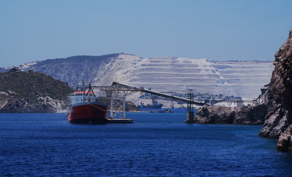
Partial view of the mine and mineral loading port.
1.3 https://commons.wikimedia.org/wiki/Cate ... yali_2.jpg
Partial view of the island, and the mine is possible. Observe a cargo ship being loaded with the mineral (pumice stone)
1.4 Agregado pesado volumoso (0 - 16 mm). Grãos de alta resistência, utilizados para refinar materiais de construção (pedra-pomes) para cimentos, utilizados para telhados ecológicos "verdes", agregados para a construção de estradas e caminhos em construções subterrâneas úmidas e de baixa resistência, construção de áreas esportivas como "campos de golfe".
Pedra pomes é usado para misturas asfálticas, revestimentos de superfície e aplicações com estabilização ou materiais não estabilizados). Para mais informações de Produtos com pedra pomes: https://www.yalibims.com/en/yalir.html
Notas:
- A pedra-pomes, também útil para a indústria têxtil no processo de desbotamento de tecidos (como o denim usado na confecção de jeans).
- A pedra-pomes é utilizada na fabricação de cimento.
- A pedra-pomes também é usada como um produto natural na forma de buchas para limpar os pés e o corpo. Ele atua como um esfoliante.
https://www.youtube.com/watch?v=Fo0f0t2O9aI
Photos of Mine:
1.1 https://commons.wikimedia.org/wiki/Cate ... yali_1.jpg
Sea view to the small islands an Strogyli (right side) and Gyali ( left side) near the islands of Nisyros and Kos (Greece):
1.2 https://www.yalibims.com/fileadmin/_pro ... 8cff91.jpg
Partial view of the mine and mineral loading port.
1.3 https://commons.wikimedia.org/wiki/Cate ... yali_2.jpg
Partial view of the island, and the mine is possible. Observe a cargo ship being loaded with the mineral (pumice stone) from the mine.
1.4.0 https://www.yalibims.com/fileadmin/_pro ... a60f62.jpg
1.4.1 https://photos.marinetraffic.com/ais/sh ... 3&size=800
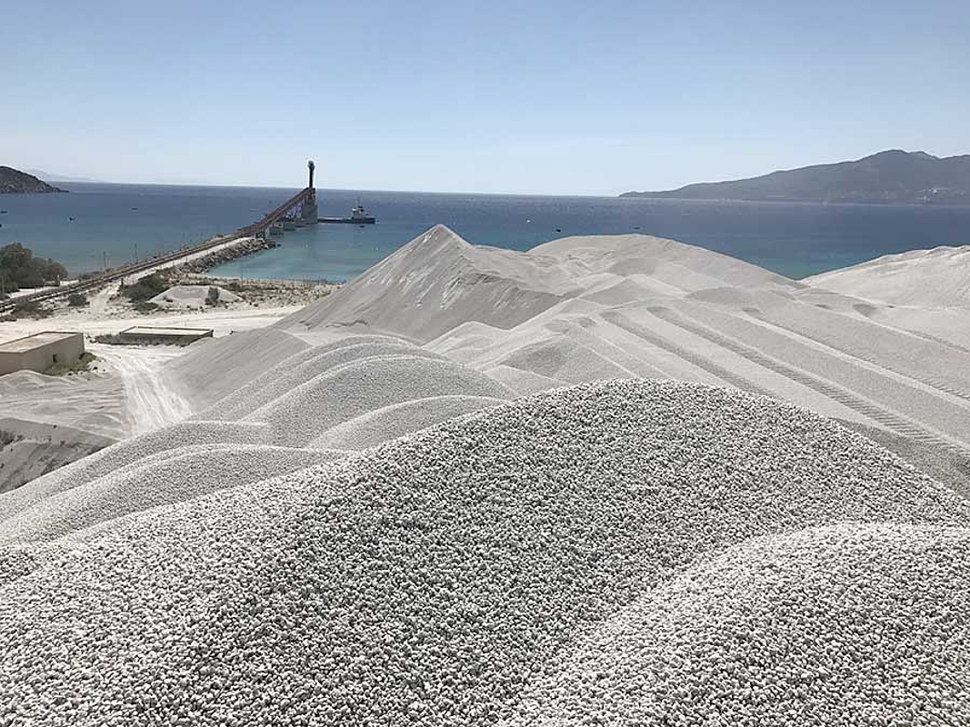
View of processed mineral deposits, port of embarkation of minerals.
1.4.2 https://steemitimages.com/DQmZiP1XqNkHZ ... 392596.jpg
Partial view of the mine. You can see a cargo ship being loaded with mineral.
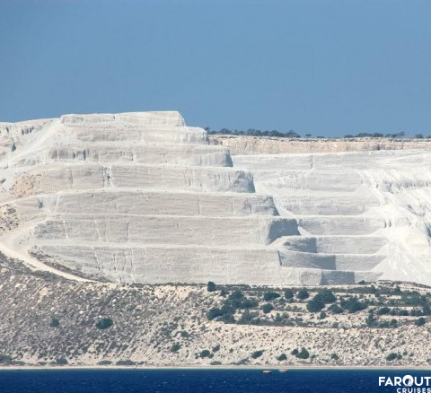
1.5 https://upload.wikimedia.org/wikipedia/ ... mining.jpg
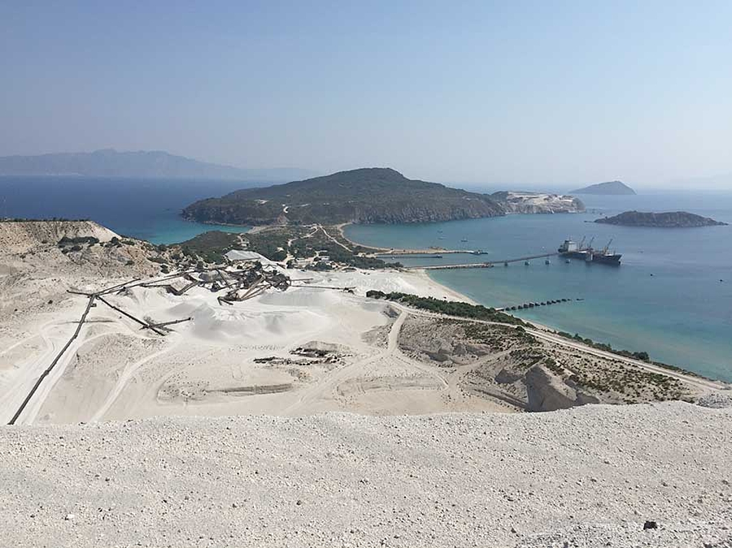
Partial view of the mining area: It is possible to get an idea of the scale of the mine's magnitude. The machines appear to be so "small" given the height of the slopes of the mine.
https://www.alaturkacruises.com/photo/r ... island.jpg
https://greece.greekreporter.com/files/ ... 68x439.jpg
https://greece.greekreporter.com/files/187189621.jpg
--------------------------------------------
1.6 Port
1.6.0 http://www.iefimerida.gr/sites/default/ ... merida.jpg
Partial view, and close to the cargo ship embarkation site.
1.6.1 http://www.iefimerida.gr/sites/default/ ... merida.jpg
Partial view, and close to the cargo ship embarkation site.
1.6.2
https://commons.wikimedia.org/wiki/Cate ... :Yiali.jpg
Partial view, and close to the cargo ship embarkation site.
1.6.3 http://wikimapia.org/3739661/Gyali#/photo/5407034
Complete view of the main part of the mine. Shipment of mineral on a cargo ship.
1.6.4 http://wikimapia.org/3739661/Gyali#/photo/3745869
View of mineral loading equipment on ships
----------------------------
1.7 Equipments
https://www.youtube.com/watch?v=WJ12MxkSnIE
This link shows a study carried out in a very complete way, on the equipment of the port of loading of minerals from the mine:
https://cubusengineering.gr/en/projects ... yros-isle/
1.7.0 http://www.iefimerida.gr/sites/default/ ... merida.jpg
Conveyor belts.
https://stefanospapaioannou.files.wordp ... 784&crop=1
Conveyor belts.
1.7.1 https://www.milosminingmuseum.com/en/th ... -of-milos/
https://www.portbook.gr/Images/BlogImages/nisyros_2.jpg
Partial view of the iconic image mine.
1.7.1 http://wikimapia.org/3739661/Gyali#/photo/3745870
industrial infrastructure (partial view) for mineral processing.
--------------------------
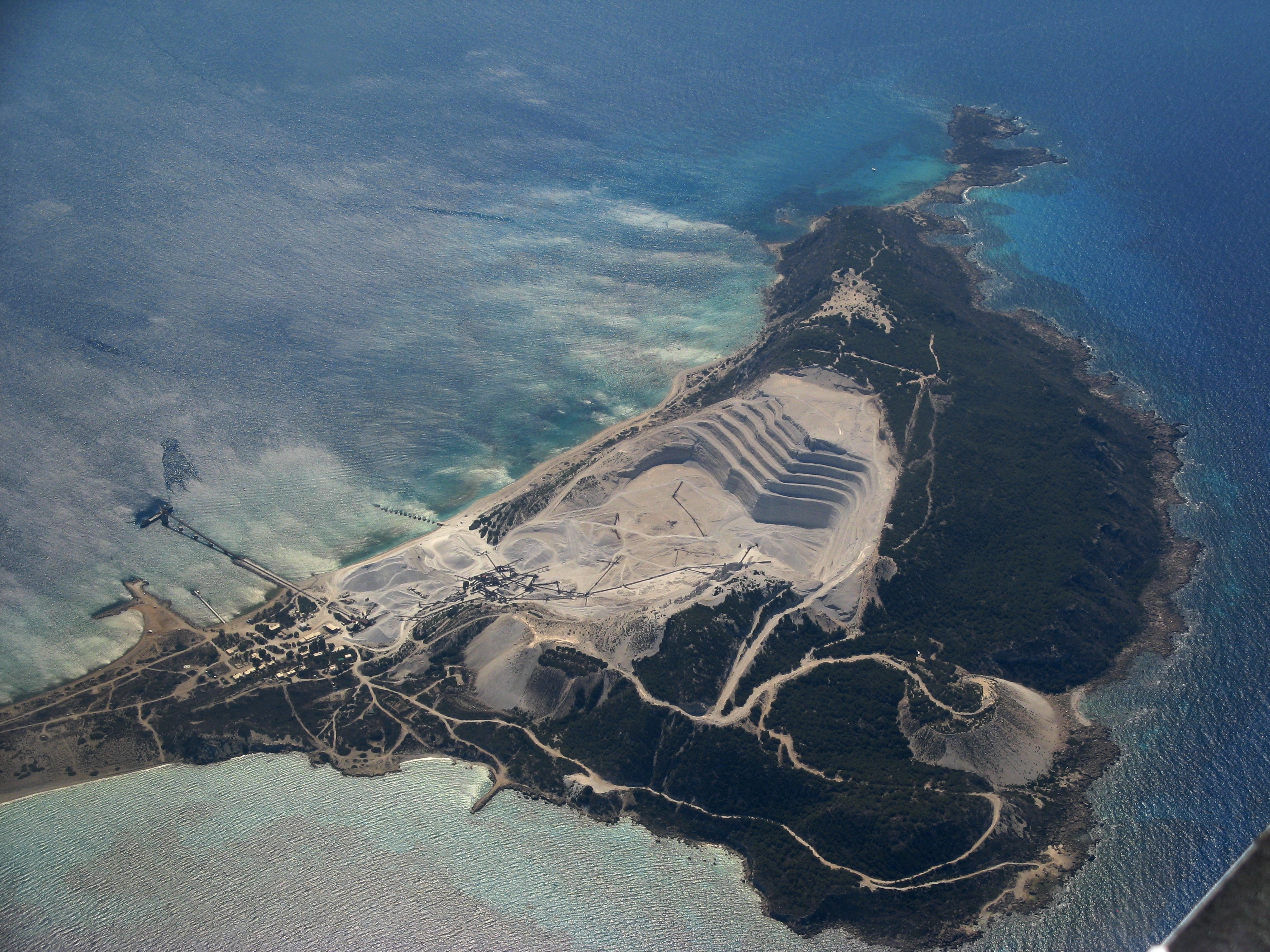
1.9 Aerial view
1.9.0 https://volcanohotspot.files.wordpress. ... yros-2.jpg
complete aerial view of the mine.
1.9.1 http://hellasga.com/gallery/var/albums/ ... 1345248934
complete aerial view of the mine.
1.9.2
https://www.nature-discovery-tours.com/ ... 769c79.jpg
Partial aerial view of the mine.
1.9.3
https://commons.wikimedia.org/wiki/Cate ... yrosWW.jpg
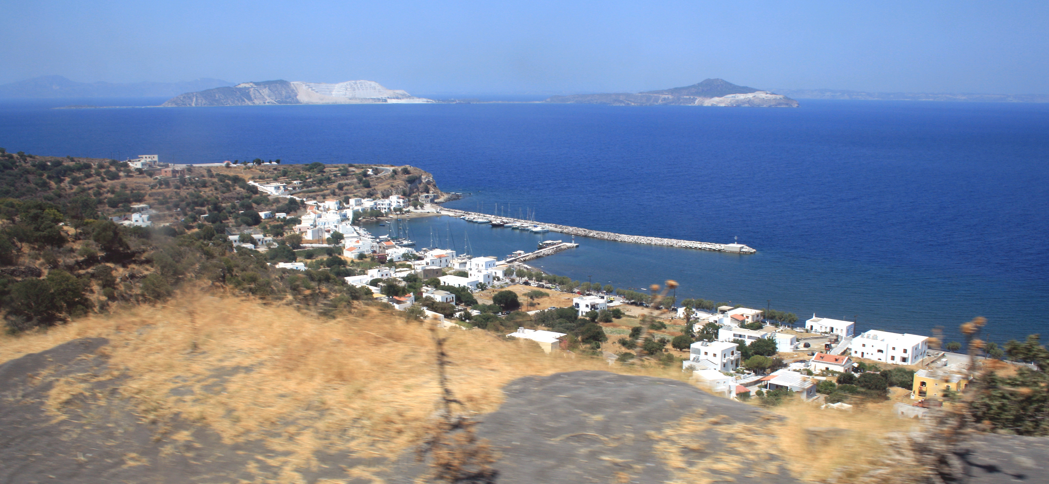
the largest island (in circular shape) is Nisyros. In front of you (in white. Mines) is the island Gyalis.
2.0 Panoramic view of Gyali Island from Nysiros Island.
At several points on the main island that forms the municipality to which the mineral island forms part, it is possible to visualize.
Ilha de Nysros: View to port and small village Pali on Nisyros island (Greece), island Gyali on horizon.
https://upload.wikimedia.org/wikipedia/ ... Pali_1.jpg
Greek Islands research support
-
plinio.lisboa.br
- Posts: 951
- Joined: 15 May 2019 16:27
- Location: Agua Boa, MT, Brazil
-
dsf.fernando

- Posts: 585
- Joined: 15 May 2017 09:16
- Location: Leiria, Portugal
- Contact:
Re: Greek Islands research support
If any Greek island may ever feature on ETS2, it may be Crete, since it's the only one with a fairly large city (Heraklion) and a sizeble road network
Proud student of Games and Multimedia in the Polytechnic of Leiria - the Portuguese capital of game development
(and still hopeful the city will feature in the game with a garage someday)
(and still hopeful the city will feature in the game with a garage someday)
-
plinio.lisboa.br
- Posts: 951
- Joined: 15 May 2019 16:27
- Location: Agua Boa, MT, Brazil
Re: Greek Islands research support
This is simply the largest pumice mine in Europe.
The heavy machinery seems to make the itinerary of Mainland Greece, is sent to Kos Island, and then goes to this island of nisyros and later is sent to the mineral exploration island that is Gyalis. In a documentary that only appears in a fraction of a second and a very long video of about 40 minutes even a truck trailer appears in the mine.
And I was wondering how it got there.
So it is possible to do some things like this with creativity but showing players very interesting things about Europe. Perhaps people do not know the most important economic relations as is the case with Pumice stones for the cement industry.
That is, a truck driver picks up a load of cement between two European cities and he has no idea that truck drivers are transporting heavy machinery to a distant island on the Greek \ Turquey border and that it produces an indispensable resource for the functioning of the cement industry.
The idea is just to make it possible for the player to take machinery from Mainland Greece or Crete to Kos Island, and then to Nysiros Island (because it has very interesting scenic things and also some common types of transport, "LAVA" operating base for mining Gyalis). What matters is that you could show players when they take heavy mining machinery the existence of the largest pumice mine in Europe.
-
plinio.lisboa.br
- Posts: 951
- Joined: 15 May 2019 16:27
- Location: Agua Boa, MT, Brazil
Re: Greek Islands research support
----- Aradena ( Αράδαινα ) village ----
Today we hear about an abandoned village on the island of Crete (and obviously has no potential to be on Euro Truck 2 in the sense of truck loads).
I consider it important to keep it registered as research material from the island of Crete. The place is very scenic and attracts thousands of tourists a year, they reach the place by bus. So if SCS Software resolves to create bus simulation games in the future, and has a tour option, this can be an important information and destination option.
Localization:
https://www.google.com/maps/place/Arade ... 24.0614836
Route: Chora Sfakion ( Χώρα Σφακίων ) - Anopolis ( Ανώπολη ) - Aradena Gorge ( Αράδαινα )
Google map route:
https://www.google.com/maps/dir/Chora+S ... 237022!3e0
(Video) route: https://www.youtube.com/watch?v=a8GxMbciD2Q
Itinerary
0:00 - 0:35 Chora Sfakion ( Χώρα Σφακίων )
0:36 - 7:00 higway (20 hairpins)
7:02 - 9:37 Anopolis ( Ανώπολη )
11:00 - 11:26 - Aradena Gorge ( Αράδαινα )
Reference: https://greece.greekreporter.com/2020/1 ... f-a-gorge/
-
MaxwellHart
- Posts: 1
- Joined: 19 Nov 2022 12:16
Re: Greek Islands research support
It's good that you talked about the mineral production in the greek islands... however I really should mention that If any Greek island could appear on ETS2, it would probably be Crete (for me it's One of the most beautiful islands in the Mediterranean), as it is the only island with a sufficiently large city (Heraklion) and a major road network. And someone already mentioned that above!
Who is online
Users browsing this forum: No registered users and 3 guests