Edtior should have feature ability to pick road slope base on slope and rise ratio with 2 nodes. For example node position A is X:31243.90 Y:23.566 Z:-1.4556 that position 1, but position B is X:31243.90 Y:23:987' Z:20.81- these cordinates I can juxtaposition and triangulate, but be better to use realistic positions based on Meters or Feet.
Togoraphy maps have elevation data in it like to set nodes to it so the hardcore wants to build maps 1:1 ratio they could. Also, makes it easier to build gentle curves and climbs.
For user generated maps just make it easy so any jpeg or ping file be uploaded without any problems into the editor without needing packing and unlocking files.
Editor wishlist
-
florence3099

- Global moderator
- Posts: 1880
- Joined: 30 Dec 2012 16:30
- Location: Goldenrod City
Re: Editor wishlist
^^This^^

Re: Editor wishlist
You can change coordinates in Node mode (N) for each road node. The positions are in meters, of course depending on your scale. Is this close to what you want or have I misunderstood you?angrybirdseller wrote:Edtior should have feature ability to pick road slope base on slope and rise ratio with 2 nodes. For example node position A is X:31243.90 Y:23.566 Z:-1.4556 that position 1, but position B is X:31243.90 Y:23:987' Z:20.81- these cordinates I can juxtaposition and triangulate, but be better to use realistic positions based on Meters or Feet.
It's impossible to generate roads from image because we don't have mesh based terrains and roads, so we would have to somehow recognize roads (and crossroads = prefabs) on the image. But it could be possible to do height maps that would change height of already made roads.angrybirdseller wrote:Togoraphy maps have elevation data in it like to set nodes to it so the hardcore wants to build maps 1:1 ratio they could. Also, makes it easier to build gentle curves and climbs. For user generated maps just make it easy so any jpeg or ping file be uploaded without any problems into the editor without needing packing and unlocking files.

Re: Editor wishlist
I am very glad if in the editor could be build a similar way as in this video:
https://youtu.be/znLTjfuQae0
And i'd like a couple of new features in the Sign Editor window:
- font scaling (only hor or only ver)
- font tracking
- layers
- object rotate
Sample: http://abload.de/img/editor_wishy8rld.jpg
And i'd like if the Properties window (Content Browser, etc.) could be fix position on editor bottom, and different options on separately tabs:
Sample: http://abload.de/img/editor_wish2evogr.jpg
Thx")
https://youtu.be/znLTjfuQae0
And i'd like a couple of new features in the Sign Editor window:
- font scaling (only hor or only ver)
- font tracking
- layers
- object rotate
Sample: http://abload.de/img/editor_wishy8rld.jpg
And i'd like if the Properties window (Content Browser, etc.) could be fix position on editor bottom, and different options on separately tabs:
Sample: http://abload.de/img/editor_wish2evogr.jpg
Thx

Re: Editor wishlist
What about a "material picker" for identifying sections of the brushed terrain? Like a "color picker" in a paint program?
Sometimes I want to brush areas in a similar style like used already, in the vicinity. But often find it hard to get an idea what materials were actually used. Yes, of course I know the browser is capable to list every known material, but sometimes the image of those patterns appear to look very different, in comparison to the brushed result.
No clue if this hard or easy, but I want to mention it, at least.
Re: Editor wishlist
In order to integrate all the stand-alone maps ...
'Prefab BATCH RENAMING' must be supported.
SiiNunit
{
editor_search_replace : .edit_replace
{
sectors[]: "*"
prefab[]: "001|rename001"
prefab[]: "002|rename002"
.
.
.
}
)
'Prefab BATCH RENAMING' must be supported.
SiiNunit
{
editor_search_replace : .edit_replace
{
sectors[]: "*"
prefab[]: "001|rename001"
prefab[]: "002|rename002"
.
.
.
}
)
http://www.facebook.com/HemilJang
Nibbana(Nirodha, Nirvana) : Please don't want anything. Please give up everything.
------------------------------------ anicca, dukkha, anatta ------------------------------------
Nibbana(Nirodha, Nirvana) : Please don't want anything. Please give up everything.
------------------------------------ anicca, dukkha, anatta ------------------------------------
-
Dummyz1992
- Posts: 5
- Joined: 15 Jan 2014 21:57
Re: Editor wishlist
Hi,
That one is a bit tricky too, because it rotates around the global axis and not around the axis of prefab. It would be nice if it could work like "move m" where you can switch the axis from global to view or local.You can also rotate with R (axis can be switched in toolbar) and mouse left button. That works also in "C" camera (maybe a little bit more properly in the next update).
Re: Editor wishlist
Another idea: add an option to temporarily hide a specific Bezier patch.
Sometimes it makes sense to partly overlap two or more of these nice patches, and then all the control points are hard to, you name it, control. To much info to compute at once, for my little brain.
Or maybe not to hide the whole mesh of a patch, rather the control points? Anyway, just a thought.
Thanks for spending a fast toggle for dropped down camera, with the latest release, BTW.
Re: Editor wishlist
Hi!
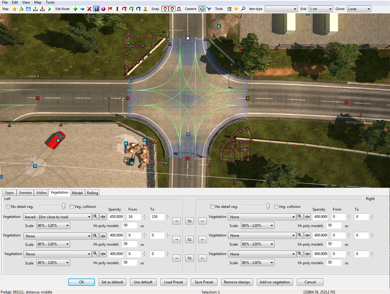
I have some ideas and questions about vegetation:
- Could you change the field "sparsity" to "density" in the road item properties panel?
Just because it makes no sense!
If I start to type the number for sparsity, after the first digit, hundreds of trees are added immediately making my game stuck for a moment and just after typing the number on, it gets sparser.
It would be much more useful if we could set the density instead of sparsity.
Simply: the higher number we type the more dense vegetation we'll get!
And another question:
It was very useful (at least for me ) that we could predefine the settings for vegetation types in vegetation.sii!
I made all my vegetation types with different min_offset-max_offset, wrap_size and scaling settings.
So it was enough to change the vegetation type in editor and it added the vegetation only in the specific zone and with specific size and density!
Now I have to set all these values manually every time I change the type!
Could you add a "set as default" button (or something similar) in the vegetation section of the road item panel? To set the current values as default for the selected vegetation type.
So if we select this type again, we'll get the defined values automatically!
Or could you give us back the possibility to define these values in the .sii and a "default" button in the vegetation section to reset the values to the predefined ones for the selected vegetation type?
IT WOULD BE VERY VERY USEFUL I think not only for me!
Thank you in advance!
I have some ideas and questions about vegetation:
- Could you change the field "sparsity" to "density" in the road item properties panel?
Just because it makes no sense!
If I start to type the number for sparsity, after the first digit, hundreds of trees are added immediately making my game stuck for a moment and just after typing the number on, it gets sparser.
It would be much more useful if we could set the density instead of sparsity.
Simply: the higher number we type the more dense vegetation we'll get!
And another question:
It was very useful (at least for me
I made all my vegetation types with different min_offset-max_offset, wrap_size and scaling settings.
So it was enough to change the vegetation type in editor and it added the vegetation only in the specific zone and with specific size and density!
Now I have to set all these values manually every time I change the type!
Could you add a "set as default" button (or something similar) in the vegetation section of the road item panel? To set the current values as default for the selected vegetation type.
So if we select this type again, we'll get the defined values automatically!
Or could you give us back the possibility to define these values in the .sii and a "default" button in the vegetation section to reset the values to the predefined ones for the selected vegetation type?
IT WOULD BE VERY VERY USEFUL I think not only for me!
Thank you in advance!
The author of HUNGARY MAP
If you appreciate our work, you can support us on the first page!
Thank you in advance!
If you appreciate our work, you can support us on the first page!
Thank you in advance!
Re: Editor wishlist
Wow, that would be great.retoucher wrote:I am very glad if in the editor could be build a similar way as in this video: https://youtu.be/znLTjfuQae0
This is not impossible, but I'm not sure we want to introduce new possible bugs with unintentional non-uniform scaling.retoucher wrote:- font scaling (only hor or only ver)
Those are not bad ideas.retoucher wrote:- font tracking
- layers
- object rotate
That's something that was planned, but due to some technical problems it's postponed for now until the properties windows change a little.retoucher wrote:And i'd like if the Properties window (Content Browser, etc.) could be fix position on editor bottom, and different options on separately tabs
You can click on an existing stamp with Shift and that will "pick" the setting into the Brush dialog. Is that what you wanted?Reinhard wrote:What about a "material picker" for identifying sections of the brushed terrain? Like a "color picker" in a paint program?
Who is online
Users browsing this forum: No registered users and 5 guests