I agree with @supersobes that electronics manufacturing would be an interesting industry for deliveries to / from. It’s also worth noting, until recently, Boise hosted a major Hewlett-Packerd (HP Office).
Also, in America Idaho is known most for one thing: potatoes. Ideally potato farms / processing plants would be a part of the DLC (or at least extensive use of the existing farm industries)
[REWORK] Idaho rework tips (originally pre-research)

Re: Idaho pre-research tips
This is another road I request to be made by the OR-140/NV-140 mapper. When it come time to make US-93 from Idaho and into Montana, I vote to task the mentioned mapper for this job. Case closed.flight50 wrote: ↑13 Nov 2018 18:31 This video is of US 93 which I am sure makes the game. It is primarily mostly Idaho, but it also ventures into Montana as well.
https://www.youtube.com/watch?v=AfmDLYSptfo&t=297s
My post are only thoughts and ideas. Don't assume it makes ATS.
Poll: Choose Next 2 ATS States
ATS Flatbed
ATS Special Transport
North American Agriculture
Poll: Out of Production Truck
Poll: Choose Next 2 ATS States
ATS Flatbed
ATS Special Transport
North American Agriculture
Poll: Out of Production Truck
-
scorpio_75
- Posts: 8
- Joined: 13 Jan 2019 05:10
Re: Idaho pre-research tips
Gooding Idaho, Plant in twin falls as well, lots of high profile dairies as well'
Re: Idaho pre-research tips
A good thread on Potato hauling:
https://www.thetruckersreport.com/truck ... es.319817/
This talks about reefer trailers mainly, but I have heard before that they (along with apples) are sometimes piled on flatbeds with a sidekit. Trying to find my source on that one.
https://www.thetruckersreport.com/truck ... es.319817/
This talks about reefer trailers mainly, but I have heard before that they (along with apples) are sometimes piled on flatbeds with a sidekit. Trying to find my source on that one.
(The Artist Formerly Known as Ranaldo20)
J. Ritter Transport- Cheyenne to Elko Part 1 (New Video! Jan 7 2022)
[ external image ]
J. Ritter Transport- Cheyenne to Elko Part 1 (New Video! Jan 7 2022)
[ external image ]

Re: Idaho pre-research tips
Okay, so when Boise is planned, logically Interstate 184 plus US 20 and US 26 should be considered. I say this, because heading toward Downtown Boise, the "child" I-184 begins at "parent" I-84 and US 30, at the Flying Wye interchange in Southwest Boise. The 184 ends at US 20 and US 26, in Garden City before heading into Downtown Boise. In Downtown Boise, 20 and 26 become a pair of one-way streets (Front and Myrtle, respectively. Eastbound is Myrtle Street, westbound is Front.) At Broadway Avenue, they join that thoroughfare until you reach I-84/US 30, and thus begins a four highway concurrency until Mountain Home, Idaho. As for Boise, itself. Downtown doesn't have many industries that could be used as a drop off, but it could be a scenic spot, to drive through Downtown toward the industry. Southeast Boise has a good amount of industries that you could pick up and drop off cargo from. Such as machine shops, where you can drop off supplies and whatnot, there's also Motive Power Industries (MPI), a manufacturer of diesel-electric locomotives. That opens the door for hauling parts for the building of railroad locomotives and whatnot. On S. Eisenman Road, there's a Utility trailer dealership which can be added. I know, we have trailer ownership and "trailer dealerships" in-game, but, why not add some physical ones, we can discover along the road. If we can discover truck and employment centers, then by George, a "physical" trailer dealership we can pass while driving should be a cinch.
The road less traveled is often the most unique one you encounter.

Re: Idaho pre-research tips
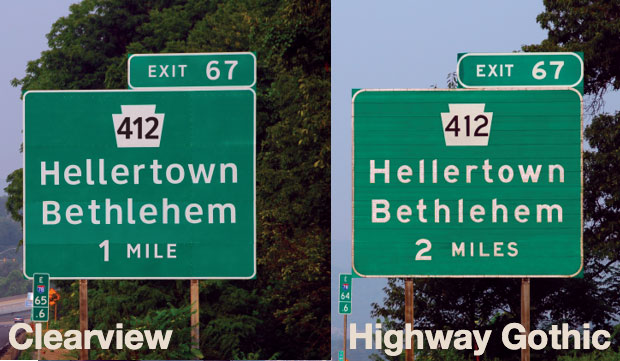
Along with Wyoming, Idaho is a clearview usage state, for their fonts, rather than FHWA Series Fonts/Highway Gothic. FHWA is synonymous with Highway Gothic.
Here's some info on that:
http://media.boingboing.net/wp-content/ ... /fonts.jpg
Here is a comparison. But, normally, in practice, shield numbers are always in FHWA and are rarely ever replaced with clearview.
https://www.aaroads.com/wp-content/uplo ... ew_map.jpg
This map shows which states use clearview.
Three strips of beacon on my toasted head
Two over easy on a roll and I'm fed
Two over easy on a roll and I'm fed

Re: Idaho pre-research tips
My personal pictures of Idaho;
https://photos.app.goo.gl/PBWMykGL7nfRoxq99
https://photos.app.goo.gl/PBWMykGL7nfRoxq99
Re: Idaho pre-research tips
I love Idaho. I wish some locals would have chimed in here for landmarks. I've spent five weeks worth of picture-taking trips here over the last few years, so I'll add a few suggestions.
Arco would best be suited as a scenery town, but I would say this signature building could be added, maybe closer to the highway so it's visible:
https://goo.gl/maps/a1kZqxd3bHPcVb1e9
I guess it could have delivery point to the grain elevator:
https://goo.gl/maps/LiksP8eeEyiaHHie7
Sinage possibility for Mt. Borah, the state's highest peak:
https://goo.gl/maps/C5uaxh5cNKuKf4Si9
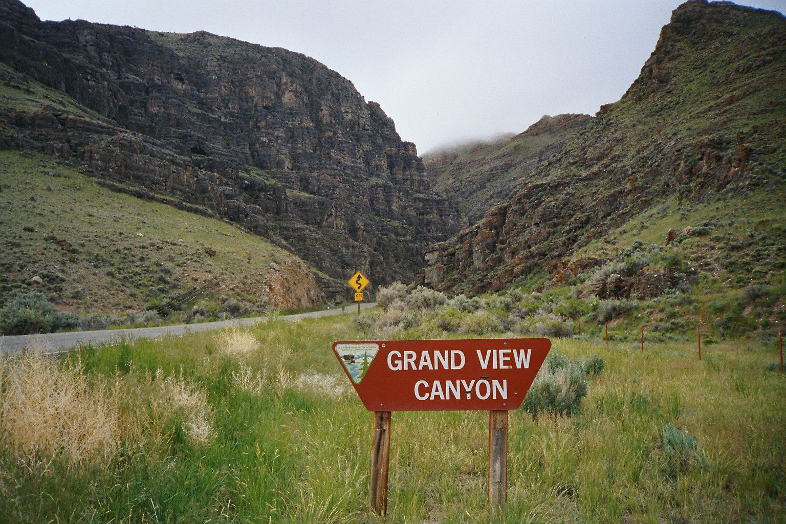
Grand View Canyon is a short, but signature section along the highway. It's signed on either end, but the signs aren't really visible on Google Maps.
https://goo.gl/maps/R5wzxfR92vdpJCNN8
I would hope ID 75 would be included in order to drive below the Sawtooth Range up to Stanley, then over to Challis. Hopefully, highway 21 as well through Bowman and down to Boise.
Having US 12 would be ideal up north to cut across the panhandle, but I don't know how much of Montana SCS would be apt to include initially. I guess they cut into Idaho for a little bit on the current release, and I think it would be hard to omit US 12, which is a great (and historical, relating to Lewis and Clark) drive along the river, and a main east-west route. That being the case, to me, it would make sense to connect Lolo with Salmon with the rest of US 93 at this time. I really hope highways 12, 21, and 75 will be included, as I fear Idaho is going to look too sparse on roads, as a few really great and super scenic roads didn't make the cut in SE Utah (12, 24, and 95), making that region empty.
So, if this little sliver of Montana is to be included, here is a large lumberyard with sawmill that could make for a drop-off:
https://goo.gl/maps/EpDNoVjDD74CwZiH6
Hamilton, and all the other connecting towns in the beautiful Bitterroot Valley could serve as a full-blown town with many industries in the map, but SCS may opt to simply use Missoula. SCS, you may wish to note the topography of the Bitterroot Mountains west of the Hamilton area. They are very unique driving along, as you're able to look up a number of drainages, as opposed to being a solid north-south ridge of mountains. I'm guessing you'll be able to replicate that to a degree, but something I thought I'd note.
Visual 1
Visual 2
Edit: I just read the general discussion thread for the first time and saw ads678's rendition here. He nailed it. That is the most ideal scenario. I might be inclined to suggest Stanley being a scenic town and Challis as a delivery town, as it's much larger, but either way, that layout is perfect.
My favorite area, namely along the Lost River Range between Mackay and Challis. The highway would need to terminate in Salmon until MT gets added, unless (see below) . . .flight50 wrote: ↑13 Nov 2018 18:31 This video is of US 93 which I am sure makes the game. It is primarily mostly Idaho, but it also ventures into Montana as well.
https://www.youtube.com/watch?v=AfmDLYSptfo&t=297s
Arco would best be suited as a scenery town, but I would say this signature building could be added, maybe closer to the highway so it's visible:
https://goo.gl/maps/a1kZqxd3bHPcVb1e9
I guess it could have delivery point to the grain elevator:
https://goo.gl/maps/LiksP8eeEyiaHHie7
Sinage possibility for Mt. Borah, the state's highest peak:
https://goo.gl/maps/C5uaxh5cNKuKf4Si9
Grand View Canyon is a short, but signature section along the highway. It's signed on either end, but the signs aren't really visible on Google Maps.
https://goo.gl/maps/R5wzxfR92vdpJCNN8
I would hope ID 75 would be included in order to drive below the Sawtooth Range up to Stanley, then over to Challis. Hopefully, highway 21 as well through Bowman and down to Boise.
Having US 12 would be ideal up north to cut across the panhandle, but I don't know how much of Montana SCS would be apt to include initially. I guess they cut into Idaho for a little bit on the current release, and I think it would be hard to omit US 12, which is a great (and historical, relating to Lewis and Clark) drive along the river, and a main east-west route. That being the case, to me, it would make sense to connect Lolo with Salmon with the rest of US 93 at this time. I really hope highways 12, 21, and 75 will be included, as I fear Idaho is going to look too sparse on roads, as a few really great and super scenic roads didn't make the cut in SE Utah (12, 24, and 95), making that region empty.
So, if this little sliver of Montana is to be included, here is a large lumberyard with sawmill that could make for a drop-off:
https://goo.gl/maps/EpDNoVjDD74CwZiH6
Hamilton, and all the other connecting towns in the beautiful Bitterroot Valley could serve as a full-blown town with many industries in the map, but SCS may opt to simply use Missoula. SCS, you may wish to note the topography of the Bitterroot Mountains west of the Hamilton area. They are very unique driving along, as you're able to look up a number of drainages, as opposed to being a solid north-south ridge of mountains. I'm guessing you'll be able to replicate that to a degree, but something I thought I'd note.
Visual 1
Visual 2
Edit: I just read the general discussion thread for the first time and saw ads678's rendition here. He nailed it. That is the most ideal scenario. I might be inclined to suggest Stanley being a scenic town and Challis as a delivery town, as it's much larger, but either way, that layout is perfect.
Re: Idaho pre-research tips
In regards to time zones: The Idaho Panhandle is in Pacific Time, whereas the rest of Idaho is in Mountain Time.

Re: Idaho pre-research tips
Let's hope that this part of US-95 will make it into the game,it sure looks a real joy to drive through there.
https://www.youtube.com/watch?v=y9373AsllVI&t=1608s
https://www.youtube.com/watch?v=5Q05q9vj0mQ&t=392s
https://www.youtube.com/watch?v=y9373AsllVI&t=1608s
https://www.youtube.com/watch?v=5Q05q9vj0mQ&t=392s
Who is online
Users browsing this forum: No registered users and 5 guests