Printable Road Atlas of ATS with all current towns, roads and landmarks - 1.49 - WIP
Re: Printable Road Atlas of ATS with all current towns, roads and landmarks - 1.43 - WIP
Many thanks for your maps - only can say - wonderful - lot of thanks - stay safe all the time, wish nice hollydays, best regards Mike
Always drive safely and appropriately - in simulation as well as in real life ")

Re: Printable Road Atlas of ATS with all current towns, roads and landmarks - 1.43 - WIP
Thanks for both your maps, very useful and much appreciated.
I can only imagine the time it needed...
I quickly saved both as ETS143.png and ATS143.png.... Computers like numbers, I like names...
I can only imagine the time it needed...
I quickly saved both as ETS143.png and ATS143.png.... Computers like numbers, I like names...
Re: Printable Road Atlas of ATS with all current towns, roads and landmarks - 1.43 - WIP
This is fantastic!
You know, I tried a similar idea a couple of years back (e. g. 1, 2), solely having driving without navigation in mind. But I used a different approach for my mapping that ended up conflicting with SCS's immense scale variations. Resolving this would have meant a ton of work, and community interest seemed to be low at the time, and SCS changed their mapping in a way that made it possible to actually use a real-life road atlas for highway navigation in ATS (like this). So the project kind of just fizzled out early on.
I'm so happy to see that someone else picked up the torch!!
Yeah, I guess that might've been me? At least I'm not aware of anybody else working on such an ATS road atlas before SenseFM ... but then, I don't use reddit (?), so I suppose if there indeed is somebody else, I might not necessarily know about it.rbsanford wrote: ↑23 Dec 2021 02:02 This reminds me of a project I saw a while ago. I can't remember if it was here or on r/trucksim, but someone set to recreating the ATS map in the style of Rand McNally's Motor Carriers Road Atlas, complete with detailed insets of major cities. Last I heard, a few people were collaborating on it, but were still working on the base map.
I'm hoping to find the time for some decent proof-reading before New Year.
Looking only at the legend, off the top of my head:
- The terrain coloring is missing from the legend. In particular, I'm wondering: Does green color signify forests or high elevation?
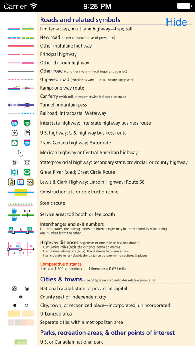
- "Highway": Should be "Multilane highway" or similar I'd say. The Americans here can check me on this, but I think just about every road on your map could be called a highway. Check out this Rand McNally legend for common U.S. terminology: screen1136x1136.jpeg
- Having separate road classes for freeways and other multi-lane highways might add value to the map.
- I'm not sure the classification of cities by population necessarily convinces me. My instinct would be to try and classify by the number of companies per city in ATS. This would add value as well. I could easily provide you with these numbers as CSV or whatever if you wanted to try this (read straight from the game files).
- The symbol X is uncommon for a mountain pass. I propose to eventually use )( instead. As you probably know, aligning that with the highway is possible in QGIS using data defined rotation.
Oh, one more thing: The term "atlas" usually refers to a map made up of several sheets. My original plan way back when would eventually have covered the 48 states with 12 map sheets, each in A4/letter format for easy self-printing. Such an approach should also be possible in principle for your atlas, by means of defining suitable layouts in QGIS, one for each map sheet. That would make printing your atlas easier (few people have got A0 printers at home).
Still, the large sheet showing the entire game world is very handy for screen usage!
For driving without GPS navigation: ATS Company/Facility Directory — C/FD
-
Trucker Nik
- Posts: 2141
- Joined: 27 Feb 2021 10:29
- Location: Trenčín, Slovensko
Re: Printable Road Atlas of ATS with all current towns, roads and landmarks - 1.43 - WIP
I have to write it again, a very nice map deeply paying homage to the author's hat down

Re: Printable Road Atlas of ATS with all current towns, roads and landmarks - 1.43 - WIP
Huge fan of this I normally drive without my GPS. I wish SCS could adopt something similar for when you open the map in the game. I know it would be just of aesthetic value but it would be nice if it looked more like an Atlas than a GPS.

Re: Printable Road Atlas of ATS with all current towns, roads and landmarks - 1.43 - WIP
Thank you for your comments @nautofon, I love the clean look in your map examples! And your project on adding driving directions to every location is also very interesting for non-GPS gameplays.
I'm from Spain and I haven't seen any Rand McNally, but I like their look a lot. In different brands, I have seen road maps with both an X symbol and a ")(" symbol for mountain passes. The second one is probably more frequent all in all so I will probably change the model.
Again, thanks a lot for your insight!
Glad you like it! But the hillshading is not mine, but a shapefile from Natural Earth (https://www.naturalearthdata.com/), the public domain dataset that I mentioned in the first post. I just filtered it a bit with QGIS and changed its transparency for it to blend better with the color background, which is also from Natural Earth.This is fantastic!I love your hillshading.
I'll make sure to take note of those suggestions and any future ones for the map's next version. I plan it to update it after any future change in the game map (hopefully already after the release of both games' 1.44 version). I'd thought about making different road classes for multi-lane highways too, since interstates and state highways seem to have different standards. I'm thinking something similar would be also a good idea for the ETS2 version of the map, since highways could be separated into the tolled ones and the free ones.I'm hoping to find the time for some decent proof-reading before New Year.
Looking only at the legend, off the top of my head:
-The terrain coloring is missing from the legend. In particular, I'm wondering: Does green color signify forests or high elevation?
-"Highway": Should be "Multilane highway" or similar I'd say. The Americans here can check me on this, but I think just about every road on your map could be called a highway. Check out this Rand McNally legend for common U.S. terminology: screen1136x1136.jpeg
-Having separate road classes for freeways and other multi-lane highways might add value to the map.
-I'm not sure the classification of cities by population necessarily convinces me. My instinct would be to try and classify by the number of companies per city in ATS. This would add value as well. I could easily provide you with these numbers as CSV or whatever if you wanted to try this (read straight from the game files).
-The symbol X is uncommon for a mountain pass. I propose to eventually use )( instead. As you probably know, aligning that with the highway is possible in QGIS using data defined rotation.
I'm from Spain and I haven't seen any Rand McNally, but I like their look a lot. In different brands, I have seen road maps with both an X symbol and a ")(" symbol for mountain passes. The second one is probably more frequent all in all so I will probably change the model.
True, it should be possible to be done with QGIS although I haven't tried it yet. I will try to give it a look, since it would be pretty useful to have a version divided in A4 sheets.Oh, one more thing: The term "atlas" usually refers to a map made up of several sheets. My original plan way back when would eventually have covered the 48 states with 12 map sheets, each in A4/letter format for easy self-printing. Such an approach should also be possible in principle for your atlas, by means of defining suitable layouts in QGIS, one for each map sheet. That would make printing your atlas easier (few people have got A0 printers at home).
Again, thanks a lot for your insight!
Re: Printable Road Atlas of ATS with all current towns, roads and landmarks - 1.43 - WIP
It was you who made the decision to use it on this map, so it's yours now in a manner of speaking.
Oh, you're most welcome. Thank you for sharing this great map!
For driving without GPS navigation: ATS Company/Facility Directory — C/FD

Re: Printable Road Atlas of ATS with all current towns, roads and landmarks - 1.43 - WIP
This is great! A marker for weigh/inspection stations would be cool. The motor carrier road atlases usually have that. Might also be helpful to mark/cross hatch/color roads where truck traffic is prohibited.

Re: Printable Road Atlas of ATS with all current towns, roads and landmarks - 1.43 - WIP
Excellent work, Thank you
Re: Printable Road Atlas of ATS with all current towns, roads and landmarks - 1.43 - WIP
This map is really good. I love to see this in the actual game. Maybe via the modding community.
Who is online
Users browsing this forum: edsor, Google [Bot], Johny1987, Majikman, RacerToft, Schinken235 and 21 guests